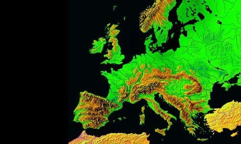
LiDAR Survey

Professional LiDAR mapping services available nationwide.
Our experts at BKS (NI) Ltd offer top-quality LiDAR mapping services.
Get in touch with us today to find out more.
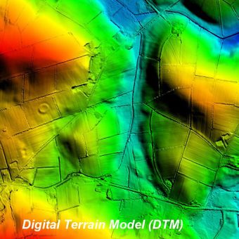
Digital Terrain Model (DTM)
A ground height model collected using LiDAR technology with non- ground features such as buildings, vegetation, powerlines & vehicles removed. The point density can range from a minimum of 1 point per square metre up to 40 points per square metre and can achieve accuracies up to +/- 50mm RMSE. Useful in most sector applications.
Aerial imagery cannot penetrate the top of trees or vegetation whereas LiDAR technology can penetrate gaps to reach the ground. Hence a more complete Digital Terrain Model (DTM)
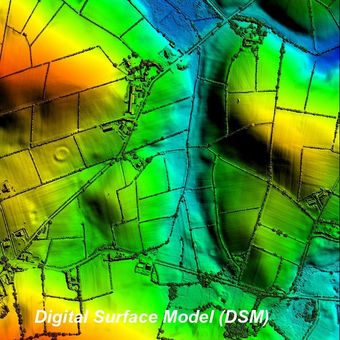
Digital Surface Model (DSM)
A surface height model is basically the same as a Digital Terrain Model (DTM), collected using LiDAR technology but includes the top (surface) of non-ground features such as buildings, vegetation, powerlines & vehicles.
LiDAR technology has a significant benefit over aerial survey methods in the creation of DTM’s especially in areas of trees and high vegetation during the growing seasons, ‘leaf-on’.
What is a LiDAR
survey?
We can undertake LiDAR surveys using highly complex systems mounted either on a fixed wing aircraft or helicopter depending on the accuracy or point density required. The point density can range from a minimum of 1 point per square metre up to 40 points per square metre and can achieve accuracies up to +/- 50mm RMSE on hard surfaces.
Give us a call
LiDAR (abbreviation for Light Detection and Ranging) is a remote sensing method that uses light in the form of a pulsed laser to measure distances to the ground. The LiDAR instrument sends rapid pulses of light at the ground and a sensor on the instrument measures the amount of time it takes for the pulse to return. As light moves at a constant and known speed the LiDAR instrument can calculate the distance between the sensor and the object it hits with high accuracy. By repeating this in quick succession the instrument builds up a complex shape of the surface it is hitting.
Modern lasers can fire light pulses at up to 500 MHZ which means up to 500,000 pulses per second.
As the sensor is moving the height, location and orientation of the instrument must be recorded to determine the position of the laser pulse at the time of sending and the time of return. This is achieved using a GPS (Global Positioning System) and an IMU (Inertial Measurement Unit) which are incorporated into the system.
All this information produces an accurate ground coordinate in plan and height for each individual laser pulse fired. Combining all the coordinates for each of the laser pulses created a 3D model which is commonly referred to as a ‘point cloud’ As this ‘point cloud’ can be extremely large in data size due to the number of points it is normally required to be gridded out to a specific spacing and tile size to make the data more manageable.
The data can be supplied as a Digital Surface Model (DSM) which includes heights of objects, such as buildings, vegetation and vehicles as well as the terrain surface, or as a Digital Terrain Model (DTM) produced by removing non-ground objects from the Digital Surface Model. This can be supplied in a wide variety of formats to suit the client’s software.
LiDAR acquisition can also be combined with the simultaneous acquisition of medium format imagery and oblique imagery for a more extensive solution. For any assistance, call us today.
LiDAR surveys
When it comes to LiDAR mapping, BKS (NI) Ltd is second to none. We offer a complete service to ensure that the aerial survey data you receive perfectly suits your requirements. We employ the latest technology to help you get more detailed data for accurate analysis and interpretation. We serve in Coleraine, Londonderry and nationwide.
Benefits of LiDAR:
- Inexpensive method
- High accuracy rates
- Quick acquisition and processing
- Denser canopy penetration
- Independent of climatic conditions
- Lesser human dependence
Contact our team today for more details on airborne LiDAR
services.
Airborne LiDAR data
Video Imagery
Video Imagery which can also be simultaneously acquired along with the LiDAR data using the latest video cameras. Cameras can be positioned to record both in a forward and down position. Used as an important additional visual aid to the interpretation of the LiDAR data.
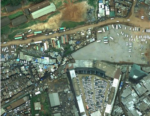
Vertical Imagery – Medium Format RGB
Medium format Colour RGB aerial imagery which can be simultaneously acquired along with the LiDAR data using the latest medium format cameras. Used as an important additional photographic aid in the interpretation of the LiDAR data.
Need aerial view and mapping information
within the United Kingdom?
within the United Kingdom?
Call us now on
028 7032 8100
Get in touch

© 2024. The content on this website is owned by us and our licensors. Do not copy any content (including images) without our consent.